Unknown's avatar

The Green Corridor (Singapore)

Image

A refreshing Sunday walk from Bukit Timah Railway Station (BTRS) up to Tanjong Pagar Railway Station (TPRS). It has been quite some time I wanted to walk the distance on the trail which now replaces the old railroad tracks now removed after the decommissioning of the railway a couple of years ago following a treaty with Malaysia. Malaysia now operates the railway starting from the Woodlands Station instead of the original starting point at TPRS. Singapore got the ownership of the piece of pristine land once occupied by the railway tracks and Malaysia got a few plots of high value land in Marina Bay.

At this time this 12.5Km strip of land is awaiting final destination and has been called the Green Corridor. Actually a white panel at the TPRS is polling from citizens who are eventually also nature enthusiasts about what options would be desirable for the final destination of the Green Corridor

I started from home at 6:00am to pick up Lynette at her place in Holland Village and then we proceeded togheter to the BTRS which is located at the side of Bukit Timah Road at about King Albert’s Road. Whoever arrives on foot from the South there is a short climb to reach the plateau of the station just were the iron railway bridge crosses at about the Sime-Darby building. Whoever comes from the North there is a much easier access road before the bridge itself.

At the station a small crowd was listening to a few historical remarks from the organizers of the Open Day and was getting ready to start the walk.

Image

The first part of the trail (up to about Queensway)is the most interesting as it crosses a forested area with waterways and a remarkable bio-diversity. In the open plains after Queensway and the Buona Vista MRT station the path widens with a number of crossings for local residents of the nearby communities.

Image

The area is dotted by magnificent black & white bungalows. Drinks can be purchased nearby a small Mosque with a very friendly imam by the name of Ali.

Image

Passed the Portsdown neighborhood, the tracks run parallel to the AYE, and the noise of the traffic and the heavy populated and built-up area are reducing the interest of the walk. As a suggestion it is advisable to end the walk at this point.

Image

Approaching the TPRS and final point of the trek is not totally friendly since a number of fences delimit the area. Actually I’d say it is quite disappointing not finding locally any posting or signage on the best way to reach the station A break in the fence is suggesting a possible approach, but later one other fenced barriers will prevent to reach the destination.

Image

After a long detour with no apparent way outs, finally we discovered another hole in the fence to reach safely Spottiswoode road and to walk around the TPRS building for the entrance.

Image

The end of the trek was reached at 11:30am after a total of 21.4Km. Next stop was a so needed wanton and noodle restaurant to replenish all the mineral salt evaporated during the 5 walking hours. Surely quite a nice day (with Lynette Foo and Alberto Carimati)

Unknown's avatar

What amount of discomfort is enough?

One may have issues with understanding foreign languages; some other with the physical pain or sore feet. There will be discomfort from wearing not perfectly laundered clothes, or for sure the lack of multiple showers every day, or again the lack of privacy in using common dorms. I think I can live with it.

What terrifies me is the absence of knowledge about the road, where are the turning points, where to stop to rest for the night. Particularly so for the extra piece of walk from Lourdes to St. Jean PdP which is almost an uncharted trail.

I am fighting against the discomfort of not being already a seasoned walker, who has done all this before and already been to all places. I fear the humility of asking for directions, or knocking at unknown doors in search for an arranged accommodation. Will I be able to learn forbearance?

Posted from WordPress for Android

Unknown's avatar

Gunung Besar Hantu

Gunung Besar Hantu, Malaysia 3.227109N, 102.012573E, peaked on April 19, 2009 at 7:30am GMT+8


This rather unknown peak in the Banjaran Titi Wangsa mountain range, is located at a relative short distance (about 50Km) from the Ampang suburb of Kuala Lumpur and yet far away from the  sometimes annoying bustling of the suburban life. The trip was made possible through the services of the Mountain Goal Adventure organization and its ineffable chief expeditioner Thong.

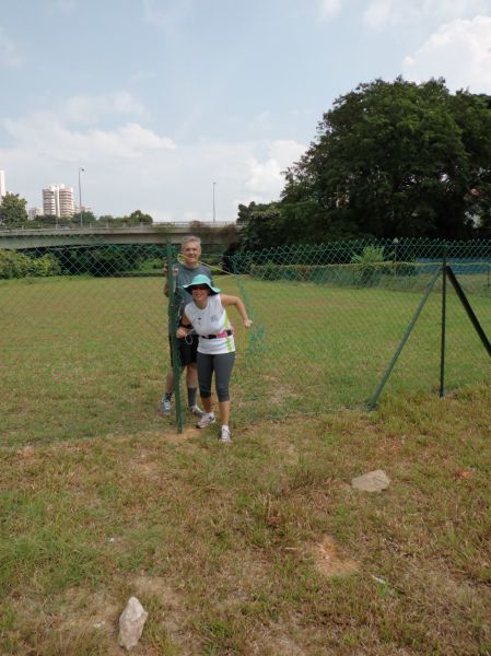
As I was looking for a no-frills, lay-down type of escape, I could not have found anything better to ensure a genuine down-to-earth, full fledged experience in tight contact with the natural beauty of Malaysia and its people. The expedition counted 14 heads including the organizers.


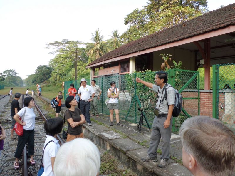
Through some fast climbing road bends, you will soon reach a quite peaceful natural lanscape with a few rural housing and villages scattered here and there.  Past the shores of a serene artificial lake, a road junction will head directly to Kampong Chennah, where everyone knows everybody and life flows like a quiet stream. The village cheered the opportunity by providing additional enthusiastic supporters who in turn climbed in the truck as occasional trip companions. Almost midway we stopped to take in a couple of Orang Asli (malay aborigens), Awang and Ali, as guides and, as I will reckon much later, mostly as teachers of natural knowledge and wisdom.In Kampong Chennah we let go of our city-car transportation, evidently not suited for the further inland roads and boarded two robust all-terrain 4×4 pick up trucks.

The road ended at a majestic waterfall, Lata Kijang, sporting an almost vertical fall of 30 meters. At the foot of the waterfall, a rocky stream forms ponds and natural pools to provide fresh water supply and refreshement to the passers-by. The sound of the stream can resemble the fated song of the Mermaids lulling the wanderer to take a prolonged rest, which we did with renewed pleasure on the way back.

From there on a steep and badly maintained iron staircase pointed vertically straight up into the forest, with no end in sight. From there on we had to count only on legs, shoulders and good spirit.

We camped after 5 hours of trekking inside the ups and down, the never ending roots and forest decay typical of the jungle treks. Thong preceded all of us and started preparing a delicious malay kampong food which was served on gigantic banana tree branches while all the tents were scattered on the scarce flat terrain all around.

Most of the rest of the time at the camp was spent in cutting off the persistent leeches that were throbbing from our legs and feet in a blood frenzy feast. Rather disgusting worms, the leeches are actually very discreet as they proceed with their feeding intent without creating the minimum discomfort. Unlike the mosquitoes and the sand flies, also abundant, which make noise and stinging hassle, leeches can be spotted only by a vague sense of ticklish or the evident large stains of blood on clothes and mostly stockings. Always remember to wear high ankle shoes and thick cotton socks with long pants. You may not be totally immune, but at least can contain the plague at an acceptable level.

While I was fumbling with my western inadequacy to the situation, Ali approached me with a shy smile, and humbly forked out a piece of moistened paper from his pocket, a small piece of the page of a newspaper, and cut it in minuscule portions almost the size of the bite of the leech and silently placed them on top. Almost immediately the profused bleeding stopped. His smile was imbued with the millenary knowledge of this proud and peaceful people continuously harassed by the harsh environment of the wilderness and the inevitable siege of the false promises of the so-called progress.

As the name of the mountain was hinting, the long equatorial night was filled up with eerie presences. The superstition handles the fear of the unknows by figuring out  monstrous and immaterial beings to be the source of the countless sounds, shrieks, cracking, whistling and pounding noises which made up a night out in the woods. A light rain was adding up the characteristic rytmic base with all the variety of responses from the large and tiny forest leaves. Tiredness made the usual miracle of donating a deep and restoring sleep troughout the night despite the quite unconfortable sleeping bag. A sudden call from nature woke me up at about 4:30am and urged me out of the tent. The long forgotten amazing show of a trillion stars, which in the meantime replaced the thick layer of clouds, left me once more speechless and astonished. Once more I was given the present of admiring the whole Milky Way, the most remote galaxies, and the fascinating and overwhelming design of the Universe.

The following morning a steady 90 minutes almost vertical climb lead us to the summit. The chilling temperature was cooperating with the muscular effort and the gratefulness of the achievement did the rest. The surrounding view was exhilarating and more so  the view and congratulations of your fellow climbers.

An ascent on a mountain is always a refreshing experience, not only for the variety of the natural lanscapes, the uniqueness of the vegetation or rock formations, the technical challenges that the trail provides during the trek.

The true experience comes from within and  from the almost rare opportunity of spending time in solitude with yourself, in a slow recovery of latent spiritual values that will surface when your inner mental noise is quieted by the phisical stress. Chemical reactions in your body enhance your senses and your capability to absorb the surrounding world  is mostly overwhelming.

I felt deep gratitude and somehow my circle of tolerance enlarged, with appreciation and contentness to an intensity which rarely I can remember in my ‘normal’ life. It’s an experience of simple things, the taste of a streaming water when you are really thirsty or the taste of natural food, often in the form of fruits or vegetable essences taken from the sources of Nature. An then the smell of  the grass, the calling of the birds and other hidden creatures, the  rustling sound of the leaves on all shape size and texture.

The discovery is also with your inner self, your thoughts and feelings, your beliefs and your fears. The slow process of awareness and acquaintance with your limits, capacity, shortcomings and values takes synergy from the slow progress through the  trail and the forest. And finally you realize that eventually time is yours to splurge, to knock you off, to get to accept you better and with it the whole universe.

The references of a mountain trek to the progress through life are manifold. Some of them I wanted to record for further meditation and later recollection:

  • The forest is apparently a totally chaotic organization. Yet, every shrub or tree has its own function and the they all live together in harmony, sharing food and light in a great display of persistence and adaptation. Most human organizations are based on the exertion of control of the few on the many and layouts are orderly and only apparently more effective. Only who thrives at the edge of chaos shall survive.
  •  In the forest all stages of life are coexistent and cooperating in mutual support and in continuous change: the young sprouts, the decay of the dead plants and the strenght of the adult trees. The contribution of each life stage is balanced and provided in abundance. Yet no resource is wasted. Learn to appreciate the sense of belonging deriving from receiving help and be grateful for it. You will learn how to offer real help in a disinterested way with no expectation of a return.
  •  The sign of the material impermanence are evident everywhere in the forest to teach a lesson of universal tolerance since nothing is eternal and immutable. So be it for your  anguish, distress and pain. And also for your pride, material satisfaction and personal success.
  •  The forest is unyielding to the walk of wanderers. All sort of unfriendly obstacles are opposing to the trek. Sometimes you have to breech into the intricacies and make your own path. The one who knows how to respect and adaptation with minimal impact will reach longer distances. The ones which need to open large passageways for greater confort will proceed slowly and will not reach far. Likewise to life.
  • You can take along only what you can carry on your shoulders. Most comfort items are heavy. Bigger bags are heavier than smaller bags. Need to learn how to source your comfort from what the mountain and the forest offer in abundance. Most of the things you consider indispensible are just jettison of the mind. The mountain values the essential over the redundant. When you leave oll your possessions at the base camp and you prepare for the final ascent, most of times in the wee morning hours, you finally understand how important is to have developed a strong body and a strong spirit, as you won’t need much else on the road ahead.
  • During the trek you might be largely concentrated in the labour of the strenuous ascent. You look down to avoid stepping into unfirm terrain, and to find around suitable support or handles to sustain your steadiness during uncertain moments. Every now and then with a thud, you head hits a low branch or a fallen tree, which you did not see before. Yet these were there for a reason to remind you that most of the time the help to sustain your progress must be seeked by looking up, to what is there for you coming from above you. There is only that much you can get from the lower grounds: most of the stronger support comes from the highest ones.

(Drafted on 25/4/2009)

Unknown's avatar

What will I really need on the road?

If this question is being asked while visiting one of those inviting outdoors shops, the answer is frightening: everything! As it is always a good advice to never going shopping for groceries when you’re hungry, likewise you should never go shopping for outdoors amenities, unless the burning need and regret from not having handy a specific tool or support item has been already experienced in a real occasion. As a matter or facts, the zero budget approach is probably still the best. Shoes and foot comfort is probably number 1 in the list; second is likely some protection from the wheather, third the minimum gear for spending the night and getting the so deserved rest. The other real necessities such as a decent shower, drinking water and food will have to be sourced locally, and so be it.

Unknown's avatar

Pilgrimage, it is.

As a proposition at the time I write this,  I’d like to challenge my comfort zone by endeavoring to tour the world on foot. Nothing new, nothing heroic, nothing spectacular with strong sponsorship backup: only a slow journey within myself and my soul.  A walking pilgrimage to connect to the millions of other souls that have done the journey before me, and also to the many whom I shall encounter on the road and also those who will start their first steps much after me. Even if this is a journey that has be be completed in total solitude, I am hoping to share the path with other pilgrims in search of their walks of life.

Unknown's avatar

The Plan

The Camino Frances is traditionally departing from St. Jean Pied-de-Port and totals 863.5 Km from St. Jean Pied-de-Port to Cape Finisterre.  It is a recent tradition for pilgrims to burn their clothes or boots at the end of their journey at Cape Finisterre: I am not sure I want to do this. If I shall feel the urge of burning something, I hope it is not going to be something material, but rather obsoleted habits or ways of thinking.

After further consideration from the late reply from Singapore Airlines to grant me a seat of the flight to Paris, I have tried other flight options to reach the starting point. In addition to the waitlisted flight to Paris, I also tried Milan which was also on waiting list, and called SQ to solicit a resolution on either option. A stop over in Milan actually would allow Raffaella to travel with me and to celebrate her birthday with the all our friends over there. A few days later, SQ confirmed my seat on the flight to Milan, therefore giving a definite hint to which itinerary was destiny for me.

Found out that Ryan Air offers a connection from Milano Bergamo to Lourdes. Then from Lourdes to St. Jean PdP it’s another complicated train connection taking a long time. But then:  “Heck, I thought, I am there to walk, so let’s walk from Lourdes instead! ”  It adds only some 145Km to the total, bringing it to a hefty 1,009Km. Now that’s a serious walk! The connection between Lourdes and St. Jean PdP is mapped in the pilgrimage chronicles and is known as the Chemin du Piemont Pyrenees.  Hope God will bless my new itinerary and provide me with the little essentials I shall need.

I shall therefore leave from Singapore on Saturday,  Sep 1st and then continue to Lourdes on September 4 arriving at about midday.

Including in and out flights it is a total of 44 days of which 33 on the walking path and 11 days of rest. In average, that is 26.2Km per day. The plan is still indicative, and will depend a lot from the weather and my physical conditions.

The itinerary I am plannign so far is the following:

Week Day Date # Distance km to the end km from the start From Overnight
Tue 4-Sep 1009.3 0.0 Milano Bergamo Lourdes, arr. 12:25, Ryan Air, FR4005
Wed 5-Sep 1 28.8 980.5 28.8 Lourdes Bruges
Thu 6-Sep 2 36.0 944.5 64.8 Bruges Oloron
Fri 7-Sep 3 24.0 920.5 88.8 Oloron Hopital St Blaise
Sat 8-Sep 4 28.0 892.5 116.8 Hopital St Blaise Garaibie
Sun 9-Sep 5 29.0 863.5 145.8 Garaibie Saint-Jean-Pied-de-Port
Mon 10-Sep 6 25.0 838.5 170.8 Saint-Jean-Pied-de-Port Roncesvalles
Tue 11-Sep 7 21.5 817.0 192.3 Roncesvalles Zubiri
Wed 12-Sep 8 22.0 795.0 214.3 Zubiri Pamplona
Thu 13-Sep 9 23.5 771.5 237.8 Pamplona Puente la Reina
Fri 14-Sep 10 22.0 749.5 259.8 Puente la Reina Estella
Sat 15-Sep 11 22.0 727.5 281.8 Estella Los Arcos
Sun 16-Sep 12 28.0 699.5 309.8 Los Arcos Logroño
Mon 17-Sep 13 29.0 670.5 338.8 Logroño Nájera
Tue 18-Sep 14 21.0 649.5 359.8 Nájera Santo Domingo de la Calzada
Wed 19-Sep 15 23.0 626.5 382.8 Santo Domingo de la Calzada Belorado
Thu 20-Sep 16 24.0 602.5 406.8 Belorado San Juan de Ortega
Fri 21-Sep 17 28.0 574.5 434.8 San Juan de Ortega Burgos
Sat 22-Sep 18 40.0 534.5 474.8 Burgos Castrojeriz
Sun 23-Sep 19 23.0 511.5 497.8 Castrojeriz Frómista
Mon 24-Sep 20 19.0 492.5 516.8 Frómista Carrión de los Condes
Tue 25-Sep 21 39.0 453.5 555.8 Carrión de los Condes Sahagún
Wed 26-Sep 22 19.5 434.0 575.3 Sahagún El Burgo Ranero
Thu 27-Sep 23 38.0 396.0 613.3 El Burgo Ranero León
Fri 28-Sep Leon
Sat 29-Sep 24 24.0 372.0 637.3 León Villadangos del Páramo
Sun 30-Sep 25 28.0 344.0 665.3 Villadangos del Páramo Astorga
Mon 1-Oct 26 20.0 324.0 685.3 Astorga Rabanal del Camino
Tue 2-Oct 27 32.5 291.5 717.8 Rabanal del Camino Ponferrada
Wed 3-Oct 28 23.0 268.5 740.8 Ponferrada Villafranca del Bierzo
Thu 4-Oct 29 30.0 238.5 770.8 Villafranca del Bierzo O Cebreiro
Fri 5-Oct 30 36.5 202.0 807.3 O Cebreiro Sarria
Sat 6-Oct 31 21.0 181.0 828.3 Sarria Portomarín
Sun 7-Oct 32 24.5 156.5 852.8 Portomarín Palas de Rei
Mon 8-Oct 33 25.5 131.0 878.3 Palas de Rei Arzúa
Tue 9-Oct 34 36.5 94.5 914.8 Arzúa Santiago de Compostela
Wed 10-Oct 35 23.5 71.0 938.3 Santiago de Compostela Negreira
Thu 11-Oct 36 24.0 47.0 962.3 Negreira Maronas
Fri 12-Oct 37 31.0 16.0 993.3 Maronas Cee
Sat 13-Oct 38 16.0 0.0 1009.3 Cee Cap de Finisterre
Sun 14-Oct Cap de Finisterre Santiago de Compostela, by bus
Mon 15-Oct Santiago de Compostela Milano, Italy by Ryan Air


Unknown's avatar

How long should the right planning time be?

As the basic groundwork for engaging in a long walk is completed, I mean when the balance between knowledge of the task and the mistery of it has reached the sweet spot, then it should be pretty much the date of departure.

If not, a painstaking process gets immediately on the way, conjuring against your still precarious decision balance. This comes in from various sources: either from people that want to to join you, it people that say it us totally useless, or too commercial, from the agony of fear of unplanned discomfort, of not being physically fit, of missing the single fundamental item that will turn the experience from barely bearable into a total hell.

Unknown's avatar

A visit to Kanchanaburi POW railway

Even if this trip has little to do with the Camino, I wish to jog in a few notes for future reference. Is has been just a long weekend outing in the countryside surrounding Bangkok in Thailand. The main attraction for the weekend tourists is to walk across the “infamous” bridge on the River Kwai, but there is no true respectful feeling left in the mass mercification of the souvenir industry which surrounds the place. Thanks to Matthew and his simple but effective trip planning, we managed to reach the end of the passenger railroad at
Nam Tok in time to hop into a local bus heading north to the Hellfire pass and Memorial Museum. This is a definite must see to make sense of the human tragedy that happened just 69 years ago starving and overworking to death over 100,000 people mostly of my father’s generation. Contrary to my belief, the Hellfire pass is not indicating the highest point, or a mountain pass. It’s actually a passageway or a gorge of about 200 meters long and 60 meter deep that has been cut by hand and explosives into the granite. The place is now immersed in a totally peaceful and bucholic athmosphere and beautifully restored by the Australian government and many survivor’s associations. The museum is the gateway to the memorial grounds and provides an abundant description of what happened between June and December 1943. From the Hellfire pass starts a 7km trail that largely uses the original railway bed as the walking track. There was an eerie feeling in the misty monsonic afternoon, which poured instantly several inched of rain almost as suddenly stopped to allow the continuation of the walk.
image

Strangely enough, the Hellfire pass is some 13Km from the last train station at Nam Tok and the only practical way to reach Hellfire pass from Nam Tok is by road. I wish that better sooner than later, in sight of the improving political relationship between Myanmar and the rest of the world, there will be a renewed effort to restore the railway tracks in between and then allowing to end the train right at Hellfire pass.

The other remarkable visit is the war cemetery in Kanchanaburi.

image

Nothing special in a war cemetery, apart from the impressive vastity of the plot of land perfectly manicured and the obsessive simmetry of the layout. Simple but effective eulogies do commemorate not just the individual casualty but contribute chorally to the remembering of all.

image

Suggestive complement to the trip was the overnightvstay at the Erawan National Park for the ritual walk to the 7 waterfalls.
image

Again it is fundamental to start the trek at the break of the day, before the ordes of day trippers will spoil the natural beauty and serenity of the stream of water.

Total cost for the three days were about TBH 2,000 (S$ 82) each sharing accommodations among the three if us.

Unknown's avatar

Energy sources on the go….

Image

This is (almost) the whole gear to ensure a supply of power to my smartphone and music player during the trip. The description is as follows:

#1 (center top right): a DC/DC converter that generates an USB low current source at 5V from two AA batteries. This is an emergency kit and assumes that I can buy batteries pretty much everywhere. Inclusive of two AA batteries plus 2 spare ones, weighs 68 grams. Comes with a white LED as torchlight.

#2 (top left): a solar powered lithium rechargeable battery with an USB output. It has an extra hi-power LED to work also as another emergency torchlight. Inclusive of the output USB cable it weighs 134 grams. It charges an exhausted phone battery in 12 hours, and under direct sunlight it recharges the internal battery in about 10 hours.

#3 (right): this is my HTC Desire S smartphone, the only communication tool I will bring along. It allows me to post text on FB and on this blog, and receive comments, emails, etc. It weighs 131 grams.

#4 (center top left): a 220/230V AC/DC adapter to source an USB 5V from a wired power line. With an european plug (two prongs) weighs 21 grams.

#5 (center bottom) : my 4GB iRiver MP3 player, USB rechargeable. With earphones it weighs 59 grams.

All together, the whole kit weighs 413 grams, or 5.16% of total targeted carry on weigh.

Unknown's avatar

Preparations…. (1)

Now that I think of it, all my life seems to be a whole walk through milestones, deadlines, target dates, things to complete before then, concatenations of delays, and responsibilities of todays actions to tomorrow’s results, and so on.

Planning for this trip, is no less. When the coundown widget showed more that 5 months were to pass before the planned walk start date, it seemed an exaggeration, an overy cautionary and an excessive planning approach. However it may not be that way necessarily. Whether we like it or not, and unless we live like hermits, we have current engagements and responsibilities we cannot simply ignore. We cannot walk away from our current life and from the lives of whoever is interdependent with us, family, friends, business relationships, work colleagues, with no sufficient advance notice and to provide with the necessary assurance of support before, during and after my absence.

Last week I have contacted ny insurance agent to study what policy could grant me a safe repartiation in case of an accident. It may take another month to review and subscribe to the one that really fits my needs. The signoff of the Letter of Undertaking for the Leave of Absence from the company I work for, will take also some time, and so will the delivery of the books and other documentation I have ordered through Amazon. I have also waitlisted me on a mileage reward flight to Paris on Septemeber 1st….the release of the booking will need some time to be hopefully cleared. Oh, and I have yet to book my return flight from Santiago to Singapore through Milano.

Needless to say, the topic of conversation in the family is now mostly concentrated on the Camino, and the sharing is not only about facts but mostly in letting the positive influences of my project to sink in the minds of the people I care the most and helping them to go beyond passive acceptance into a full active support. I will start to hang maps of the Camino all around the house and will prepare the pins for them to track my daily progresses. I will have movies and other documentaries of the surroundings of the Camino for them to see what I shall see. 

I need to inform all my groups of Friends, in Singapore and in Italy, and respond to their comments, emails and blog postings, suggestions, contacts (there is always someone’s friend who has walked the Camino already…). I have also to organize the charity initiative to allow my personal sponsors to pledge for the kilometers I will eventually walk……

All this takes time. And this is also all about the Camino: breeding a steady mind towards a project which uses time as a central theme, and develops through the appreciation of time as the best companion of our life journey.

I also want to go through and document my thoughts, enthusiasm and fears while I prepare mentally for the trip. The spirit is already at an all-times high since a few days, that is since the projects is taking a concrete shape. On the physical side, I am not sure how to train so much in advance: maybe a few Sundays runs, maybe losing a few Kg, maybe controlling my diet to build up some long ago lost muscles…. this suggests the idea (alas, the engineer inside never sleeps!) to design a mood-o-meter to report the % of the development and attainance of the KPI. (Key Preparation Indices).

On the next post, perhaps.